

The Gulf Coast is bracing for the potential of a significant hurricane landfall just three days from now, as what will likely become a tropical storm — and then potentially Hurricane Helene — is organizing in the Caribbean Sea.
The National Hurricane Center labeled a tropical disturbance southwest of the Cayman Islands as Potential Tropical Cyclone #9 Monday morning. Although the storm has not yet officially formed, attaching this label allows forecasters to issue an official forecast track as well as watches and warnings for the system.

CBS News
The storm is poorly organized Monday afternoon, with its low-level center currently displaced from the mid-level swirl. The system is expected to become more vertically stacked and organize quickly on Tuesday, when it will likely become Tropical Storm Helene.
Tropical storm warnings and hurricane watches are in effect for portions of western Cuba and the Yucatan Peninsula of Mexico as the storm strengthens further by the middle of the week. Those with travel plans to Cancun, Playa del Carmen and Cozumel are urged to check with their carriers and consider altering their plans.
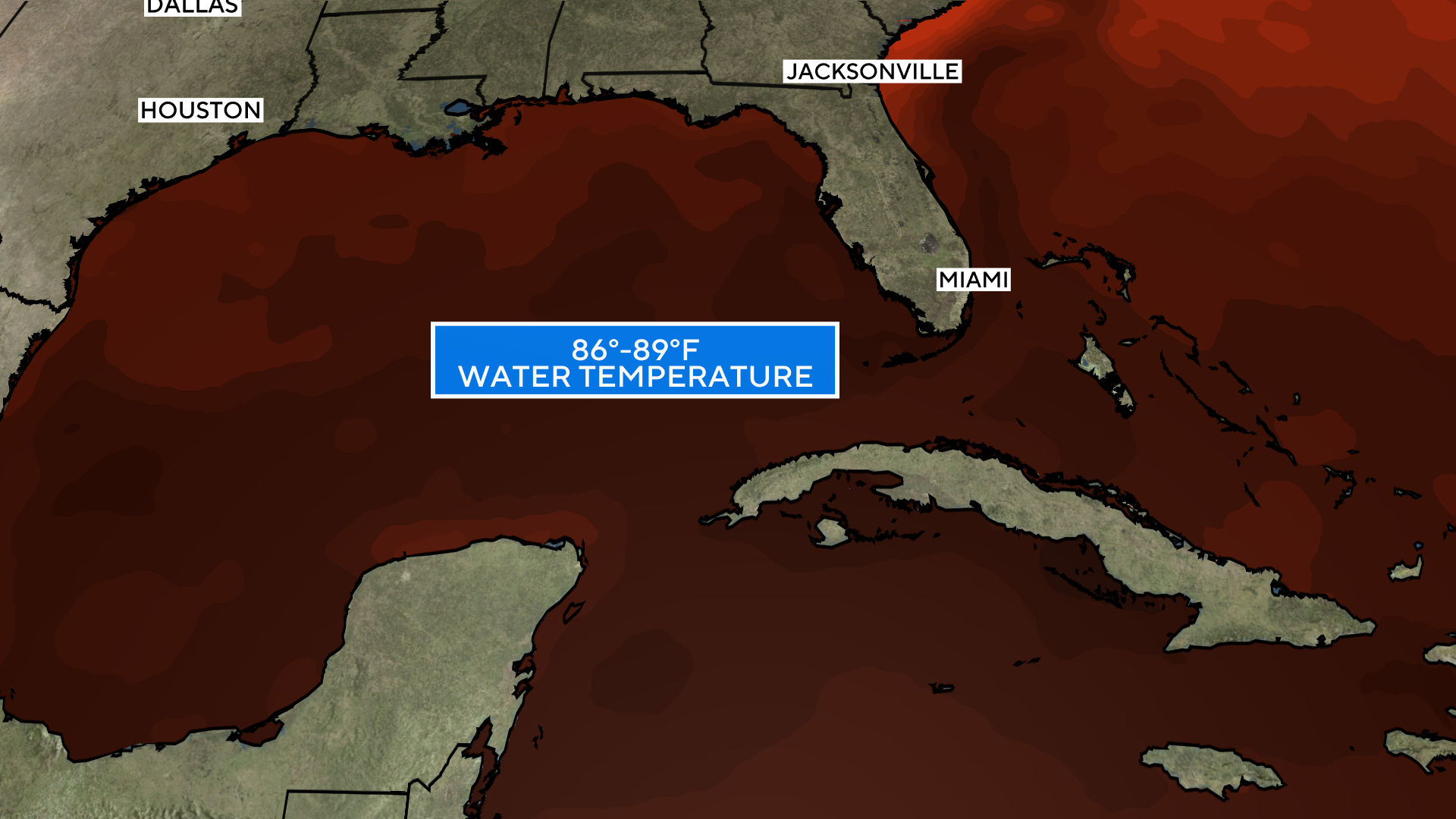
Helene is expected to accelerate toward the eastern Gulf Coast on Wednesday, trekking over record-warm water in the Gulf of Mexico that would act like jet fuel in intensifying the storm.
Brian McNoldy, senior research associate at the University of Miami Rosenstiel School of Marine, Atmospheric, and Earth Science, recently noted that ocean heat content in the Gulf of Mexico is the highest on record. Warm water is a necessary ingredient to strengthen tropical systems.
Sea surface temperatures in the path of Helene are as warm as 89 degrees Fahrenheit — 2 to 4 degrees F above normal. These record water temperatures have been made significantly more likely by human-caused climate change, according to Climate Central. The North Atlantic Ocean as a whole has seen record warm temperatures in 2024, storing 90% of the excess heat from climate change produced by greenhouse gas pollution.
CBS News
In addition to record-warm waters fueled by climate change, Helene is expected to travel directly over the Loop Current, an area of exceptionally warm water that travels up from the Caribbean into the eastern Gulf of Mexico before squeezing through the Florida Straits and traveling northward as the Gulf Stream.
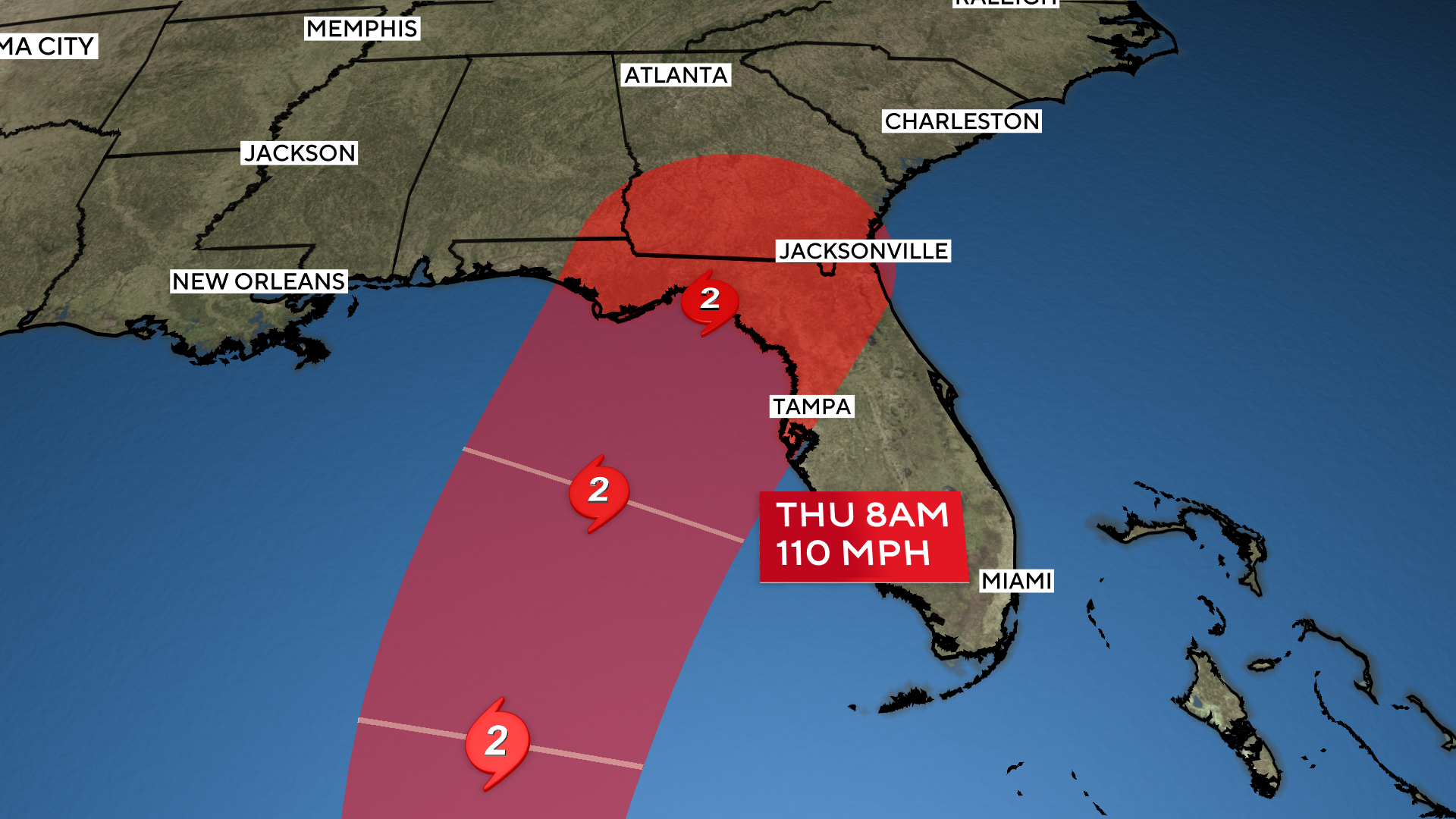
Due to warm water and an otherwise favorable environment with high levels of storm-nurturing moisture and low levels of storm-killing wind shear, there is high confidence that Helene will be the third of four landfalling U.S. hurricanes so far this year to rapidly intensify. Rapid intensification criteria is met when a storm gains at least 35 mph wind speed in 24 hours or less.
Official projections from the National Hurricane Center call for Helene to gain 80 mph of wind speed by Thursday, turning the 30-mph tropical disturbance into a powerful Category 2 storm with 110 mph winds at landfall. Some high-resolution computer forecast models suggest an even stronger, major hurricane.
CBS News
Residents on the west coast of Florida are encouraged not to focus on the center line of the forecast track, as Hurricane Helene will be a large, fast-moving storm with impacts that extend well away from the center, especially on the storm’s east side. Communities from the Florida Keys northward to Tampa could experience destructive storm surge flooding, even if the center of Helene remains farther west.
Florida Gov. Ron DeSantis has declared a state of emergency for 41 counties ahead of the storm’s approach.
The Gulf Coast of Florida is especially susceptible to storm surge flooding from hurricanes due to the shallow waters and shape of the coastline.
As the storm organizes further and creeps closer to the U.S., storm surge watches and hurricane watches will likely be issued for much of the Florida coastline.